  • State of Arizona
  • Visit OpenBooks
  • Ombudsman Citizens Aide
  • Register to Vote
Arizona Interagency Wildfire Prevention Logo
Arizona Interagency Wildfire Prevention

Main menu

  • Home
  • Wildfire Situation
  • Wildfire Prevention
  • Fire Restrictions
  • Wildfire Resources
  • About Us
  • Home
  • Downloadables

Main menu

  • Home
  • Wildfire Situation
  • Wildfire Prevention
  • Fire Restrictions
  • Wildfire Resources
  • About Us

Downloadables

livingwithfire_bnr.jpg

Living with Fire

Be Red Cross Ready:
Wildfire Safety Checklist


Be Red Cross Ready
Pets & Disaster Safety Checklist

livingwithfire_tn.jpg

Living with Fire - A Guide For The Homeowners

EMBER AWARE:

Will Your Home Survive When the Embers Arrive?
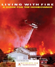
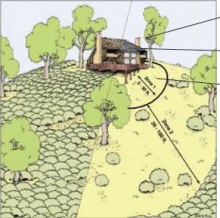
[PDF] A New Look at Understanding
HAZARD ASSESSMENT
METHODOLOGIES

def-space-pdf.jpg

How To Reduce Fire Hazards


How To Reduce Fire Hazards
“Creating Defensible Space"

firewise-mont.jpg

Firewise Construction - Firewise Landscaping

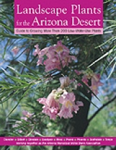
Landscape Plants for the Arizona Desert

LandscapeAZDesert.jpg

Landscaping Plants for the Arizona Desert

Firewise Plant Materials for 3,000 ft. and Higher Elevations


InciWeb

InciWeb is an interagency all-risk incident information management system. 

InciWeb is an information tool which serves as a source of official public information on high-visibility, high-complexity, or long duration incidents. 

Not all active incidents will be featured here. 

The agency and/or incident management team for the incident is responsible for initiating and maintaining information.

InciWeb

Arizona Emergency Information Network

AZEINLogo.png

AZEIN Logo
Arizona's online source for real-time emergency updates, preparedness and hazard information


    • The Maricopa County Air Quality Department has declared a No Burn Day for Thursday, March 6
    • Pile Burning Planned in the Prescott Basin on the Bradshaw Ranger District
    • Pile burns planned Wednesday, and Thursday
    • Areas of County Within Apache-Sitgreaves National Forest to Enter Stage 1 Fire Restrictions Friday
    • Fuels projects support wildfire risk reduction underway in Yavapai County
    More

Agency Websites

Use this Interactive Map to help determine who manages the lands where you plan to recreate.

[Click and Zoom-In]

LandMgmtMap.PNG

Arizona Map showing land management in different colors by agency management

Contact the land management agency where you plan to recreate:

National Forests - USDA  Forest Service  [Green]

Bureau of Land Management - Arizona [Yellow]

National Park Service - Arizona[Purple]

Bureau of Indian Affairs - Western Region [Orange]
Tribal Partners 

US Fish and Wildlife Service Refuges - Arizona [Sage]

Arizona Department of Forestry & Fire Management [Blue]

Arizona State Land Trust [Blue]

Arizona State Parks [Blue]

Military [Red]

Private Lands [White]

Arizona State Seal
Arizona Interagency Wildfire Prevention

Footer Nav

  • Statewide Policies
  • Site Map